
MoRTH deploys advanced tech for landslide mitigation on hill roads
MoRTH adopts advanced tech for landslide mitigation on hill roads.

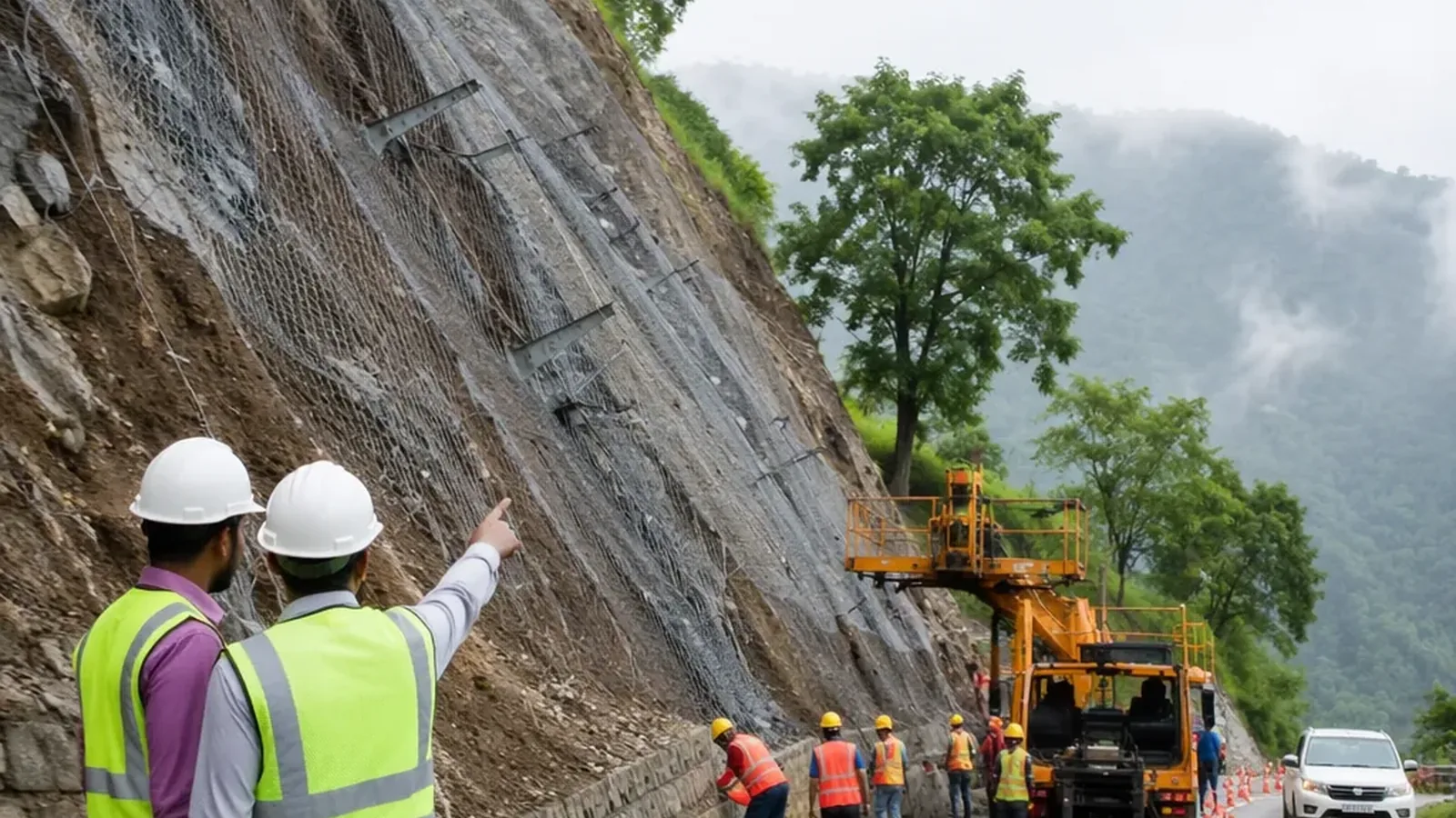
The Ministry of Road Transport and Highways (MoRTH) has initiated advanced measures to mitigate landslides and enhance climate resilience on hill roads. Following recent disasters like the Uttarkashi cloudburst, MoRTH is deploying Interferometric Synthetic Aperture Radar (InSAR) technology along a 100-km stretch of the Char Dham route in Uttarakhand to monitor ground movements and issue early warnings. Additionally, real-time monitoring systems are being planned for the Parwanoo-Solan section of NH-5 in Himachal Pradesh to track landslides, groundwater shifts, and rockfall zones.
To strengthen economy infrastructure in geologically sensitive areas, MoRTH has partnered with scientific institutions such as the Geological Survey of India (GSI) and IIT Roorkee. Geological maps and landslide susceptibility data are now integrated into the planning stages of highway projects. The ministry has also signed agreements with THDC India Limited and DGRE for specialized geohazard mitigation in Uttarakhand and Arunachal Pradesh.
A phased construction approach has been introduced, focusing on slope stabilization before road building begins. Advanced technologies like drones, LiDAR surveys, and digital terrain models are being used to assess risks and implement site-specific solutions such as soil nailing, high-tensile steel meshes, and efficient drainage systems.
MoRTH is also adopting global standards for rockfall protection, mandating certifications like European Technical Assessment (ETA) for products. These efforts aim to reduce repair costs, minimize disruptions, and ensure safer highways in India's hill states.
With nearly 16,788 km of National Highways in hill regions, these initiatives reflect a shift from reactive disaster management to proactive resilience building, ensuring long-term safety and reliability of critical road infrastructure.
Frequently asked questions
What technology is MoRTH deploying for landslide mitigation on hill roads?
MoRTH is deploying Interferometric Synthetic Aperture Radar (InSAR) technology along the Char Dham route in Uttarakhand.
What is the purpose of real-time monitoring systems being planned by MoRTH?
The real-time monitoring systems aim to track landslides, groundwater shifts, and rockfall zones on the Parwanoo-Solan section of NH-5 in Himachal Pradesh.
Which institutions has MoRTH partnered with for geohazard mitigation?
MoRTH has partnered with the Geological Survey of India (GSI) and IIT Roorkee for geohazard mitigation.
What approach is MoRTH taking for construction in geologically sensitive areas?
MoRTH is using a phased construction approach that focuses on slope stabilization before road building begins.
How many kilometers of National Highways are there in hill regions of India?
There are nearly 16,788 km of National Highways in hill regions of India.
You may also like
 Accident
At least 7 dead in Uttarakhand tunnel collapse, rescue efforts ongoing
 Technology
Hong Kong’s HK$200 Million AI City Brain to Focus on Infrastructure Monitoring
 Business
Madhya Pradesh’s Debt Crosses ₹5.33 Lakh Crore After Fresh ₹4,500 Crore Loan
 Politics
Local Bodies Not Obliged to Fund KSRTC Depots, Kerala Minister Says
Most read
- 1
Air China Adds Extra Flight for Passengers Stranded in Fuel-Starved Cuba
- 2
Western disturbance to bring rain, hail and strong winds across north India
- 3
Yogi Adityanath Directs No Occupied Houses Be Demolished for Achhalda Bridge
- 4
Gwalior Temple Truck Crash Kills 12, Injures 28-29 Devotees During Navratri
- 5
Schools Shut in Five Tamil Nadu Districts, Including Chennai, Amid Heavy Rain
Comments
No comments yet. Be the first to comment.