
Mumbai on orange alert as heavy rainfall expected through Sunday evening
IMD maintains orange alert for Mumbai with heavy to very heavy rain expected through Sunday evening. Gradual easing forecast from September 14.

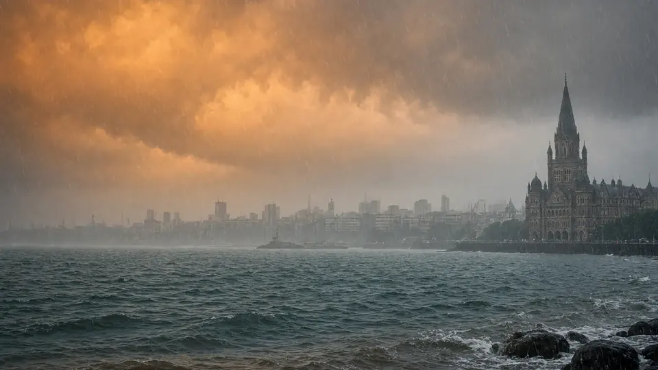
The India Meteorological Department has maintained Mumbai on an orange alert, warning of heavy to very heavy rainfall at isolated places, while extending weather advisories across multiple districts in Maharashtra until 8.30 a.m. on September 14, 2026.
IMD Forecasts Gradual Easing After Sunday
The Regional Meteorological Centre, Mumbai, issued its evening district forecast at 6 p.m., stating that heavy to very heavy rain was "very likely" at isolated places in the city. The intensity is expected to taper off in the coming days, with moderate rain forecast for September 14, light to moderate rain on September 15 and 16, and light rain on September 17. The IMD's official district-warning portal has listed September 13 among the current warning dates.
The timing of the rainfall coincides with significant tidal activity along the Mumbai coast. The Brihanmumbai Municipal Corporation reported that a 4.46-metre-high tide occurred at 1.05 p.m., followed by a low tide of 0.44 metres at 7.13 p.m.. The corporation has forecast the next high tide at 1.38 a.m. on September 14, 2026, when the sea level is expected to reach 4.43 metres, followed by a 1.21-metre low tide at 7.17 a.m..
Multiple Risks as Weather Department Issues Cautions
The meteorological department has cautioned that spells of heavy rain can trigger localised waterlogging or flooding in low-lying and urban areas, alongside traffic and transport disruptions. Additional threats include the uprooting of weak trees and damage to poorly maintained structures. The IMD has also warned about rough sea conditions along the Konkan coast and the possibility of landslides or rockfalls in vulnerable areas.
Konkan Belt and MMR Face Varied Intensity
In the Mumbai Metropolitan Region and adjoining Konkan belt, Thane has been forecast to receive heavy to very heavy rainfall at isolated places, while Raigad could see isolated heavy rain. Palghar faces a more severe forecast, with thunderstorms and lightning accompanied by heavy to extremely heavy rainfall at one or two places.
State-Wide Warnings Span Multiple Districts
Nandurbar has been placed in the highest warning category shown in the IMD bulletin, with thunderstorms, lightning and heavy to extremely heavy rain forecast at one or two places. The Nashik ghats could face heavy to extremely heavy rain along with thunderstorms and lightning, while Dhule could receive heavy to very heavy rainfall accompanied by thunderstorms and gusty winds of 40-50 kmph.
Heavy rain accompanied by thunderstorms, lightning and gusty winds of up to 40-50 kmph has also been forecast at isolated places in Jalgaon, Nashik, the Pune ghats, Chhatrapati Sambhajinagar and Jalna. Similar heavy-rain and thunderstorm warnings are in place in parts of Vidarbha, including Akola, Amravati, Buldhana and Washim. The overall intensity is expected to reduce considerably from September 14, 2026, in most parts of the State.
Source: The Hindu
Frequently asked questions
What is the current weather alert status for Mumbai?
Mumbai is on an orange alert with heavy to very heavy rainfall expected at isolated places through Sunday evening. The India Meteorological Department has extended weather advisories across multiple districts in Maharashtra until 8:30 a.m. on September 14, 2026.
When will the heavy rainfall in Mumbai end?
The intensity is expected to taper off after Sunday. Moderate rain is forecast for September 14, light to moderate rain on September 15 and 16, and light rain on September 17.
What are the main risks associated with the heavy rainfall?
The IMD has cautioned that heavy rain can trigger localised waterlogging or flooding in low-lying and urban areas, traffic and transport disruptions, uprooting of weak trees, damage to poorly maintained structures, rough sea conditions along the Konkan coast, and the possibility of landslides or rockfalls in vulnerable areas.
Which areas in Maharashtra are facing the most severe weather forecast?
Nandurbar, Palghar, and the Nashik ghats face the most severe forecasts, with thunderstorms, lightning, and heavy to extremely heavy rainfall at one or two places. Several other districts including Thane, Raigad, Dhule, and parts of Vidarbha also have significant rainfall warnings.
You may also like
 Weather
Maharashtra's Monsoon Stalls as Delhi Prepares for Light Rain
 Weather
India Braces for Below-Normal Rainfall; Telangana Set for Above-Average Precipitation
 Weather
Monsoon Strengthens in Kerala, Idukki Sees Highest Rainfall
 Politics
Election Commission extends voter verification deadline in Maharashtra to August 8
Most read
- 1
Tesla audits Chinese suppliers to scale up Optimus robot production
- 2
Former minister Lakhan Singh Rajput to inaugurate temple bhandara at Shri Chakreshwar Mahadev
- 3
Firozabad BSA finds four government schools locked during inspection
- 4
Tamil Nadu dengue cases fall for third consecutive year to 17,049
- 5
Social workers stage silent protest at Fufund railway station for train halts
Comments
No comments yet. Be the first to comment.