
Ganga crosses warning mark in Kanpur, displaces over 150 families from homes
Water levels in both the Ganga and Pandu rivers have risen sharply in Kanpur, submerging several low-lying and residential areas across the city.

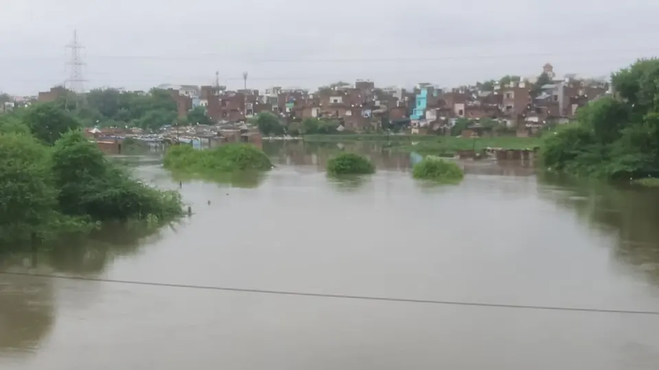
Water levels in both the Ganga and Pandu rivers have risen sharply in Kanpur, submerging several low-lying and residential areas across the city. The Ganga has crossed the warning mark at the Kanpur barrage, while the Pandu river, also known locally as Pandav river, has caused severe flooding in residential neighborhoods.
According to the irrigation department, the water level at the Kanpur barrage has exceeded the warning point of 114 meters, with upstream levels recorded at 114.220 meters and downstream at 114.070 meters. The danger mark stands at 115 meters. All 30 gates of the barrage have been opened and up to 3.61 lakh cusecs of water is being released. As a result, the Ganga is flowing toward the danger mark from Bithoor to Atal Ghat, and low-lying areas in Katri have been flooded with water ranging from half a foot to two feet deep in fields and roads.
The worst-hit area has been Barra-8, where the Pandu river overflowed following continuous rainfall and erosion. In the Mehrban Singh ka Purwa slum settlement, floodwater entered residential homes, completely submerging the area. More than 150 families have been forced to evacuate their homes and have taken shelter with relatives.
The administration has set up a flood relief camp at Barra Composite School in I Sector. Tehsildar Vinay Dwivedi confirmed that the camp is operational and affected families are being provided all possible assistance. MLA Mahesh Trivedi has distributed relief materials to 100 affected families. The administration has appealed to people living along both riversides to remain alert and move to safer locations as water levels continue to rise.
Frequently asked questions
What is the current water level at the Kanpur barrage?
The water level at the Kanpur barrage has exceeded the warning point of 114 meters, with upstream levels recorded at 114.220 meters and downstream at 114.070 meters. The danger mark is set at 115 meters.
How many families have been displaced by the flooding in Kanpur?
More than 150 families have been forced to evacuate their homes due to flooding, particularly in the Mehrban Singh ka Purwa slum settlement in Barra-8. These families have taken shelter with relatives.
What relief measures are being provided to affected families?
The administration has set up a flood relief camp at Barra Composite School in I Sector. MLA Mahesh Trivedi has distributed relief materials to 100 affected families, and the camp is providing all possible assistance to those affected.
Why are water levels rising in Kanpur's rivers?
Water levels in both the Ganga and Pandu rivers have risen sharply due to continuous rainfall. The Pandu river overflow was also caused by erosion, and all 30 gates of the Kanpur barrage have been opened to release up to 3.61 lakh cusecs of water.
You may also like
 Crime
Crime
Kanpur businessman murder solved, son arrested as mastermind for contract killing
 National
Kanpur Villagers Allege Illegal Sale of Government Land With Official Collusion
 Politics
Month-Long Public Service Programmes Under Seva Sankalp Campaign
 Uttar Pradesh
Big Twist In Akhilesh Dubey Case: Hotelier Suresh Pal Backtracks On Statement
Most read
- 1
Tesla audits Chinese suppliers to scale up Optimus robot production
- 2
Former minister Lakhan Singh Rajput to inaugurate temple bhandara at Shri Chakreshwar Mahadev
- 3
Firozabad BSA finds four government schools locked during inspection
- 4
Tamil Nadu dengue cases fall for third consecutive year to 17,049
- 5
Social workers stage silent protest at Fufund railway station for train halts
Comments
No comments yet. Be the first to comment.